

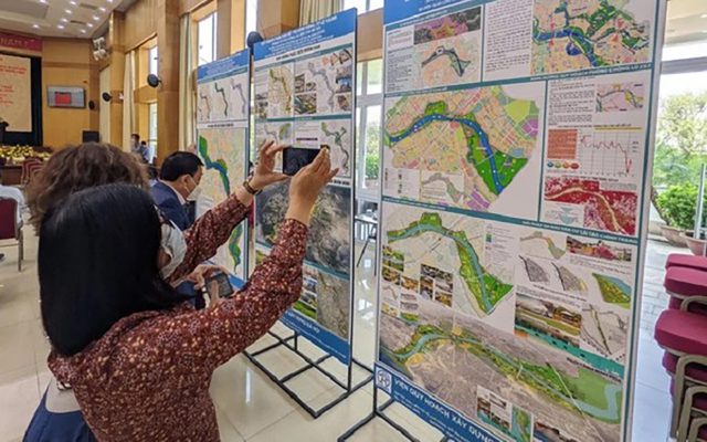
On the afternoon of April 5, the Hanoi People’s Committee held a conference to publicize the Red River urban zoning planning projects, scale 1/5000 (the section from Hong Ha bridge to Me So bridge) and the urban zoning plan of the Red River. Duong river area (R6), scale 1/5000 (section from Bac Cau bridge to Phu Dong bridge) in 13 districts of Hanoi city.
These are important planning projects newly approved by the city. Hanoi approved in recent times, attracting the attention of the people and at all levels and sectors. The projects will contribute to completing 100% of the zoning planning in the City.
The approved urban zoning planning projects mentioned above will be an important legal basis for detailed planning, urban design, construction management according to the planning in the locality, and the formation of spatial axes. The space features a green corridor, with the main functions being public works, green parks, cultural history, tourist services, and entertainment symbols of the Capital. These plans contribute to the promotion of socio-economic development; improve people’s living conditions towards civilization, modernity and sustainable development.
The Red River urban zoning planning project is the legal basis for the renovation, embellishment, and reconstruction of the existing population system to be preserved and maintained; preservation of monuments and architectural works of historical value, combined with exploitation of new development land fund to create an urban landscape appearance on both sides of the Red River. This is also the typical spatial axis of the green corridor with trees and water surface, the dominant landscape of the central urban area; Forming the cultural-historical spatial axis – the ecological landscape of West Lake – Co Loa…
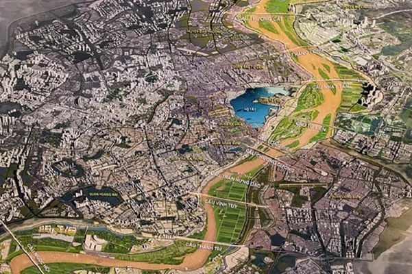
Perspective illustrating the overall scheme of the Red River urban zoning planning project, scale 1/5000 (Section from Hong Ha bridge to Me So bridge).
This content has very practical significance to stabilize people’s life in the area outside the dyke, meeting people’s expectations for many years.
As for the urban subdivision planning project of Duong river, this is a specific area that must comply with the requirements of the Dike Law: The river section has a high standard dike system to stabilize the flow and prevent flooding; increase the flood diversion capacity of the Red River in combination with the improvement of waterway traffic to link with the regional network.
This is also an area with a land fund for exploitation and development on both sides of the river in the direction of ecological green trees, combining tourism, preserving and maintaining the natural landscape to create the face of urban areas, combining create embellishment and reconstruction of existing residential villages, preserve valuable monuments and architectural works.
Do not let extra land area arise outside the planning
In order for the above urban zoning planning projects to be put into practice immediately, the Chairman of the City People’s Committee assigned the Department of Planning and Architecture to check and confirm records, drawings and management regulations according to the plans. planning project in accordance with the content of decisions of the City People’s Committee; At the same time, the Department also assumes the prime responsibility to coordinate with the People’s Committees of districts and the Hanoi Institute of Construction Planning to publicize the approved planning for agencies, organizations, businesses and people to know. presently.
People’s Committees of districts and districts: Dan Phuong, Bac Tu Liem, Tay Ho, Ba Dinh, Hoan Kiem, Hai Ba Trung, Hoang Mai, Thanh Tri, Thuong Tin, Me Linh, Dong Anh, Long Bien, Gia Lam are responsible for establishing boundary drawings of 1/500 scale of existing residential areas that are existing, protected, etc., will be transferred to the Department of Agriculture and Rural Development for certification that it is in accordance with the flood prevention and control planning and the dyke planning approved by the Prime Minister. Government approved.
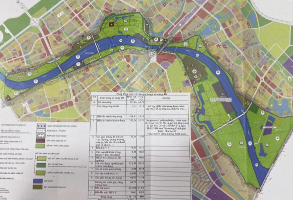
Planning diagram of Duong river subdivision, scale 1/5000 – Photo: Pham Tuan
Organize detailed planning of 1/500 scale to embellish existing residential areas to exist and protect; determine the specific legality of land use for each land plot in the existing residential area, serving as a basis for granting land use right certificates and construction permits according to regulations;
Inspect, manage and supervise construction according to the planning, handle cases of construction in contravention of the planning according to its competence and provisions of law. Review and adjust relevant investment programs, plans, master plans and projects in the locality in accordance with the approved subdivision planning.
Districts also need to closely manage the protection corridors of dykes, embankments, riverbanks, riverbanks and floating beaches in accordance with the law on dykes, preventing encroachment and violations, especially after forming into roads in riverbanks as planned. There are solutions to manage existing concentrated residential areas that exist and are protected according to regulations; not to generate additional residential land area, number of households living outside the dyke, outside the planning.
At the same time, review and develop plans and roadmaps for relocation of residential areas in areas where the river is narrow, at risk of unsafety in the event of large floods and households violating the law on dykes, located within the dyke protection area, the area is subject to dangerous landslides according to regulations…
CafeF.vn