

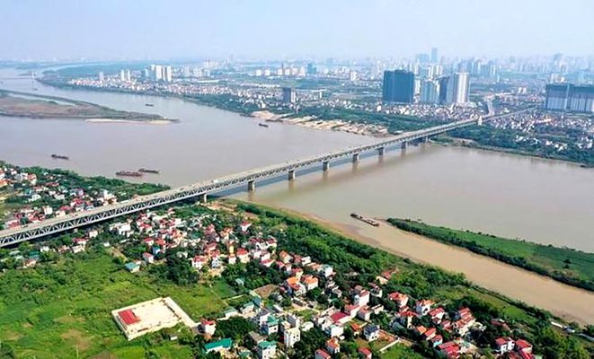
Hanoi People’s Committee has just issued Decision No. 1045/QD-UBND approving the Red River urban zoning planning project. The project has a scale of 1/5000 (section from Hong Ha bridge to Me So bridge) with a scale of nearly 11,000 ha, belonging to the administrative boundaries of 55 wards and communes in 13 districts.
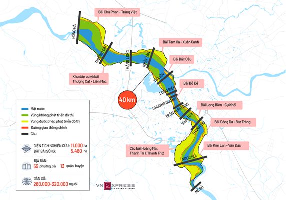
The subdivision planning covers an area of approximately 11,000 hectares. In which, the Red River accounts for 3,600 ha (33%), the riverbank land is over 5,400 ha (50%). The rest of the area is a built-up area consisting of historic villages and riverside neighborhoods…
According to the approved plan, the Red River urban subdivision has a length of 40 km, stretching from Hong Ha bridge to Me So bridge, belonging to the administrative boundaries of 55 wards and communes of 13 districts including: Hoan Kiem, Ba Dinh, Tay Ho, Bac Tu Liem, Hai Ba Trung, Hoang Mai, Long Bien, Dan Phuong, Me Linh, Dong Anh, Gia Lam, Thuong Tin and Thanh Tri.
The Red River urban subdivision has the main function of the Red River flood drainage space passing through the central urban area. Spatial planning for flood drainage from grade 1 dike (left bank) to existing special grade dike (right bank), based on the following principles: Do not improve existing dike routes, do not build new dikes; does not narrow the flood drainage space, does not propose a new dike solution in the old dike (the new dyke drainage space in the old dike drainage space); does not change the objectives and standards of flood prevention and control of the river system.
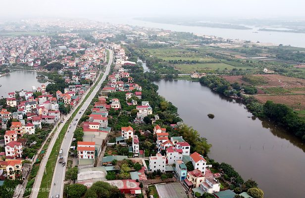
The project is carried out with the aim of forming the cultural spatial axis – ecological landscape of West Lake – Co Loa. Along with that, the renovation, embellishment, and reconstruction of the existing residential system will be maintained and protected according to the flood prevention and control planning and the dyke planning of the Red and Thai Binh river systems. In addition, preserving monuments and architectural works of historical value, combined with exploiting the new development land fund to create an urban appearance on both sides of the Red River.
Illustration
Currently, Hanoi has studied the planning of eight Red River banks. In which, 6 new areas are studied and built at the rate of 5% (about 1,590 ha) including: Thuong Cat – Lien Mac, Hoang Mai – Thanh Tri, Chu Phan – Trang Viet, Dong Du – Bat Trang, Kim Lan – Van Duc. Particularly, the area of Tam Xa – Xuan Canh is researched and built at the rate of 15% (about 408ha).
Regarding traffic, for roads, the city will build two new urban axes along the Red River. Specifically, the Hong right bank axis from Hong Ha bridge to Thanh Tri bridge is planned with a cross-sectional scale with at least 4 motorized lanes and 2-4 mixed lanes. Along with that, the left bank axis from Thuong Cat Bridge – Ta Hong dike – Vinh Tuy bridge – Thanh Tri bridge is planned with a cross-sectional scale of 40 – 60m wide (6 – 10 lanes).
Regarding the dike routes passing through the inner city (Au Co, Nghi Tam, Yen Phu, Tran Nhat Duat, Tran Quang Khai, Tran Khanh Du, Nguyen Khoai streets) grade is inter-regional road with scale of 4 – 10 lanes . In which, other major urban and inter-regional roads have a width of 40 – 50 m (6 – 8 lanes).
Regarding the main roads in the area, Hanoi built on the basis of upgrading existing dike sections such as Hong left dyke, Hong right dyke, Lien Mac – Thuong Cat section, the southern section of Thanh Tri bridge is determined to have scale of 4-6 lanes (including the road to collect the dike foot).
The area’s main roads, newly built regional roads have a cross-sectional width of 17 – 30 m, 2 – 4 lanes. Some sections of the route passing through existing residential areas and the section adjacent to the river can be studied to narrow the summer section (but still ensure enough lanes on the route) to limit ground clearance.
In new construction areas, Hanoi will build zoning roads with a 2-lane cross-section. In some sections of the route through existing residential areas and villages, it is possible to study the reduction of sidewalks to reduce the volume of ground clearance.
According to the plan, the project identifies the construction of 6 new road bridges across the Red River, including Hong Ha Bridge and Me So Bridge on Ring Road 4 (size of 6 expressway lanes, 2 mixed lanes); Thuong Cat Bridge and Ngoc Hoi Bridge on Ring Road 3.5 (scale of 6 motorized lanes and 2 mixed lanes); Tu Link Bridge connects urban trunk roads along the corridors on both sides of the Red River (scale of 6 motorized lanes and 2 mixed lanes); Tran Hung Dao Bridge connects Tran Hung Dao Street to the area of Long Bien District (scale of 6 motorized lanes and 2 mixed lanes).
In addition, the city will build additional phase 2 of Vinh Tuy bridge. Along with that, the city will study, supplement and expand Thang Long Bridge and Bac Cau Bridge across Duong River on the urban main road along the Red River.
Source: CafeF; vnexpress